File:C+B-Galilee-Map.JPG

Original file (1,131 × 1,600 pixels, file size: 718 KB, MIME type: image/jpeg)
Captions
Captions
Summary
[edit]
| Description |
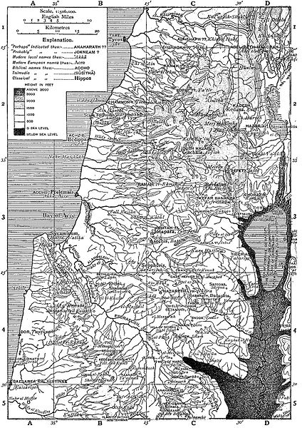
English: An illustration from the Encyclopaedia Biblica, a 1903 publication which is now in the public domain.
Map for article "Galilee". Map of Galilee and Esdraelon. It would be helpful if someone could add colour to the map (specifically, the oceans, rivers, and lakes), to clarify it/ improve the aesthetic. INDEX TO NAMES (this has not been proofread or formatted - if you wish to make any corrections / formatting, please do so) Article references refer to Encyclopaedia Biblica articles. The references following some names having no biblical equivalent are to passages that mention them. The alphabetical arrangement ignores prefixes : Ain ( spring ), Blr( well ), el ( the ), J. (Jebel, mt. ), Jisr( bridge ), Kefr ( village ), Kh. (Khirbat, ruin ), L. (lake), Alt., N. (Nahr, river ), Nabi ( prophet ), K. (river), Sahl ( plain ). Sheikh ( saint ). Tell ( mound ), Umm ( mother ), IV. (Wddy, valley ). Abel-beth-maachah, Di Abil el-Kamh, Di W. Abillin, B3(JipHTAH-EL) tell Abu Kudes, 84 AbuSheba,C3(GALiLEEi.,7) Accho, 63 Achshaph??Ci Achzib, 62 Acre, 63 bay of Acre, 63 [][][][][][][][][][][][][][][][][ 7) Taricheae, 04 (GALILEE ii., wady et-Tawahm, 03 et-Tell, 03 (BETH-SAIDA) Tiberias, 03 sea of Tiberias, 03, 4 jebel et-T6r, C4 Tyre, Bi Tyrus, Bi wady Yabis, DS GABESH) Yafa, 4 (JAPHIA) Yakuk, 3 Yanuh, Ci, 2 Yarmflk, D4 (GOLAN) Ya tir, 2 Yenima, CD4 (APIIEK, 3, c) Zer In, C^ nahr ez-Zerka, A4 ez-Zlb, Ba ] |
||
| Date | |||
| Source | An illustration from the Encyclopaedia Biblica, a 1903 publication which is now in the public domain | ||
| Author | no idea - see source | ||
| Permission (Reusing this file) |
|
Licensing
[edit]
This media file is in the public domain in the United States. This applies to U.S. works where the copyright has expired, often because its first publication occurred prior to January 1, 1929, and if not then due to lack of notice or renewal. See this page for further explanation.
|
 | |
 |
This image might not be in the public domain outside of the United States; this especially applies in the countries and areas that do not apply the rule of the shorter term for US works, such as Canada, Mainland China (not Hong Kong or Macao), Germany, Mexico, and Switzerland. The creator and year of publication are essential information and must be provided. See Wikipedia:Public domain and Wikipedia:Copyrights for more details.
|
File history
Click on a date/time to view the file as it appeared at that time.
| Date/Time | Thumbnail | Dimensions | User | Comment | |
|---|---|---|---|---|---|
| current | 16:34, 21 October 2009 | | 1,131 × 1,600 (718 KB) | Newman Luke (talk | contribs) | {{Information |Description={{en|1=An illustration from the Encyclopaedia Biblica, a 1903 publication which is now in the public domain. Map for article "Galilee". Map of Galilee and Esdraelon. '''It would be helpful |
You cannot overwrite this file.
File usage on Commons
There are no pages that use this file.
File usage on other wikis
The following other wikis use this file:
- Usage on fr.wikipedia.org