File:Aerostat Deployment (51525216658).jpg

Original file (480 × 640 pixels, file size: 136 KB, MIME type: image/jpeg)
Captions
Captions
Summary[edit]
| Description |
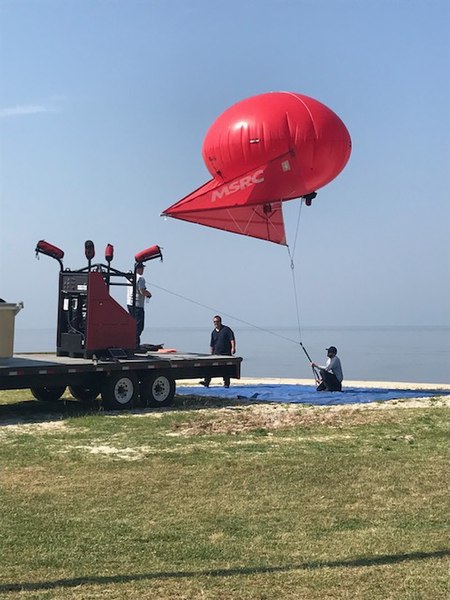
May 20, 2018 St. Tammany Parish, Louisiana An oil spill removal organization’s (OSRO) spill response operating team (OSRT) practices deploying an inflatable aerostat during an oil spill response exercise. These vehicles can be equipped with a variety of sensors and are used to provide overhead surveillance of an oil spill. Operators use the data from the sensors on the aerostat to monitor the trajectory of a spill and guide response units to the thickest patches of oil. BSEE Preparedness Analysts from the Oil Spill Preparedness Division (OSPD) regularly observe these types of activities to ensure compliance with regulations and to monitor the overall vigor of the oil spill preparedness and response community. Photo by: BSEE
|
|||||||||||||
| Date | ||||||||||||||
| Source | Aerostat Deployment | |||||||||||||
| Author | Bureau of Safety and Environmental Enforcement BSEE | |||||||||||||

.jpg&action=edit§ion=1)
| Camera location | | View this and other nearby images on: OpenStreetMap |
|---|
.jpg¶ms=030.335075_N_-090.044800_E_globe:Earth_type:camera_source:Flickr_&language=en)
Licensing[edit]
.jpg&action=edit§ion=2)
| This image was originally posted to Flickr by bseegov at https://flickr.com/photos/123443813@N05/51525216658. It was reviewed on 3 August 2022 by FlickreviewR 2 and was confirmed to be licensed under the terms of the Public Domain Mark. |
File history
Click on a date/time to view the file as it appeared at that time.
| Date/Time | Thumbnail | Dimensions | User | Comment | |
|---|---|---|---|---|---|
| current | 22:41, 2 August 2022 | | 480 × 640 (136 KB) | Geo Swan (talk | contribs) | Transferred from Flickr via #flickr2commons |
You cannot overwrite this file.
File usage on Commons
There are no pages that use this file.
.jpg&oldid=827599043)